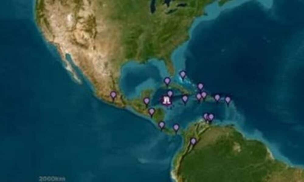
A powerful 7.6-magnitude earthquake struck the Caribbean Sea on the afternoon of Saturday, February 8, 2025, raising concerns and triggering tsunami alerts across several Central American and Caribbean nations. The quake’s epicenter was located near the Swan Islands in Honduras, at a depth of approximately 10 km. Due to its intensity and location, the tremor was felt in various coastal areas, including Honduras, Belize, Mexico, the Cayman Islands, Jamaica, Cuba, and Puerto Rico. The immediate impact led to the activation of alert systems, port closures, coastal evacuations, and the reinforcement of safety protocols in multiple countries that could be affected by waves generated by the seismic event. The Caribbean region is historically vulnerable to earthquakes due to the movement of the North American and Caribbean tectonic plates, which frequently produce high-magnitude seismic events.
Local authorities in Honduras and Cuba reported structural damage to some buildings, as well as temporary power outages in areas closest to the epicenter. Residents in affected regions reported intense shaking, with shattered windows and displaced household objects. Some roads suffered damage due to landslides, complicating mobility in mountainous areas.
In Belize, Costa Rica, and Nicaragua, coastal populations were warned of potential abnormal sea level rises, prompting many residents to seek higher ground as a precaution. While some regions experienced minor sea-level fluctuations, no major destruction caused by tsunamis has been reported so far.
Tsunami Alerts and Immediate Response from Authorities
Following the earthquake’s detection, the Pacific Tsunami Warning Center activated emergency protocols, issuing alerts for several coastal regions at risk. The system indicated the potential for waves between 1 to 3 meters high to reach areas of Cuba, Honduras, and the Cayman Islands, while other locations might experience smaller sea level changes. In response, local governments ordered preventive evacuations, closed ports, and suspended activities in high-risk zones.
The rapid issuance of alerts allowed many coastal communities to take precautionary measures. In Cancún and Tulum, Mexico, authorities advised tourists and residents to move away from the shoreline, while in Cuba, civil defense teams reinforced security in flood-prone areas. The alert for Puerto Rico and the U.S. Virgin Islands was canceled about 45 minutes after its initial issuance as models indicated a low risk of significant waves in these areas.
Infrastructure Impact and Reports from Affected Areas
The earthquake caused damage to some infrastructure, particularly in Honduras, where partial building collapses and road cracks were reported. Residents in cities near the epicenter described strong shaking and mass evacuations to open areas. In Cuba, historic buildings were temporarily closed for structural evaluation to ensure their safety.
Power outages were temporarily reported in parts of northern Honduras, including coastal regions, as authorities inspected distribution networks. In Belize, reports indicated that boats were swept into the open sea due to ocean receding, a common phenomenon associated with major seismic events.
Seismic History of the Caribbean Region
The Caribbean region sits atop a complex system of tectonic plates, including the Caribbean Plate, the North American Plate, and the Cocos Plate, which interact along multiple geological faults. This interaction results in a significant frequency of high-magnitude earthquakes, many of which have caused severe impacts throughout history.
Over the past 50 years, several earthquakes of magnitude 7.0 or higher have been recorded in the region, including:
- 2010: A 7.0-magnitude earthquake devastated Haiti, killing over 230,000 people and leaving millions homeless.
- 2018: A 7.5-magnitude earthquake in the Gulf of Honduras triggered tsunami warnings across Central America.
- 2009: A 7.3-magnitude earthquake occurred near the Cayman Islands, though no major damage was reported.
Seismic activity in the Caribbean continues to be monitored by various international geological institutes, which warn of the potential for future high-intensity tremors.
Depth and Magnitude Explain the Earthquake’s Impact
The 7.6-magnitude earthquake classifies the event as “major” on the Richter Scale, meaning it has the potential to cause significant structural damage depending on the epicenter’s location and the population density of affected areas. Additionally, the earthquake’s depth, estimated at 10 km, contributed to the widespread effects. Shallower earthquakes tend to have more severe surface impacts, while deeper quakes may dissipate some of their energy before reaching populated areas.
Preventive Measures and Emergency Plans Taken by Affected Countries
Nations in the region implemented various measures to mitigate the earthquake’s impact and a possible tsunami:
- Honduras: Coastal monitoring and suspension of maritime activities to prevent risks to fishermen and boaters.
- Mexico: Beach closures in Quintana Roo and evacuation of small vessels.
- Cuba: Inspection of historic buildings and reinforcement of security measures in critical infrastructure.
- Jamaica: Alerts issued for coastal communities and monitoring of sea-level variations.
The coordinated actions of authorities were essential to avoiding major casualties and ensuring public safety.
Potential Consequences and Developments from Seismic Activity
After high-magnitude seismic events, aftershocks are common. These secondary waves can vary in intensity and may continue for days or even weeks after the main earthquake. Authorities recommend that people stay alert and follow established safety protocols.
Researchers continue monitoring possible subsequent geological shifts, which could indicate new areas of risk. Studies on the Swan Islands Transform Fault, where the earthquake occurred, are essential for predicting future patterns and developing mitigation strategies.
Reinforcement of Earthquake Preparedness and Disaster Response Strategies
This earthquake reinforces the necessity of robust disaster preparedness and response strategies. In vulnerable regions like the Caribbean and Central America, investments in resilient infrastructure, improved early warning systems, and community training programs can save lives. Strengthening international cooperation in seismology and civil defense is crucial for ensuring effective responses and minimizing the impact of future seismic events.
Veja Também:
 Como cada signo vivencia o Natal? – 24/12/2024 – Astrologia
 Resultado Mega-Sena 2815 com prêmio acumulado de R$ 32 milhões nas Loterias Caixa
 Hulu revoluciona mercado de streaming com conteúdos exclusivos e expansões globais
 uma história de amor e desafios fora das pistas
 Bianca Censori choca no Grammy 2025 ao surgir sem roupa no tapete vermelho
 Virgínia Fonseca e Zé Felipe apostam em educação bilíngue para filhas, investindo R$ 2.600 por mês em escola de Goiânia