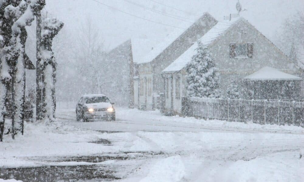
A powerful winter storm began impacting Michigan’s Upper Peninsula (U.P.) on Tuesday, March 4, bringing extreme weather conditions that are set to disrupt daily life for the next few days. Characterized by initial rain, near-freezing temperatures, and a shift to heavy snow, the slow-moving system prompted local authorities to issue high-risk weather alerts. Forecasts predict snow accumulations reaching up to 24 inches in higher elevations, paired with strong winds boasting gusts of up to 45 miles per hour, creating a dangerous mix that will likely make roads treacherous and severely reduce visibility, especially near Lake Superior.
The day started with scattered rain and a risk of icy surfaces as morning temperatures hovered near the freezing point. This early scenario triggered a weather alert in effect until 10 a.m. As the day progresses, temperatures are expected to rise slightly above freezing, with showers persisting—rain in the eastern U.P. and a mix of rain and snow in the west. By evening, the low-pressure system driving this storm will shift precipitation into wet, heavy snow, beginning a more severe phase that will extend into Thursday’s early hours. Conditions are forecast to worsen significantly after 7 p.m., marking the start of a second weather alert.
With widespread snow expected overnight, the storm’s peak will hit between Tuesday night and Wednesday morning. Areas like Marquette, Baraga, and western U.P. counties such as Gogebic and Keweenaw will bear the brunt, with snow accumulations ranging from 12 to 24 inches depending on elevation and lake proximity. The combination of heavy snow and strong winds will challenge residents and authorities alike, with the worst conditions anticipated through Wednesday evening.
Storm’s impact across the Upper Peninsula
Driven by a complex system originating in the Central Plains, this storm’s intensity is set to test Michigan’s Upper Peninsula resilience. Wednesday morning will see wet, heavy snow blanketing the region, turning roads sloppy and complicating commutes. As temperatures drop into the 20s°F (-6°C) during the day, the snow will transition to a lighter, powdery consistency, making it prone to blowing. Northeasterly winds, sustained at 20 to 25 miles per hour with gusts exceeding 45 miles per hour, will whip up blowing snow, causing poor visibility and near-whiteout conditions along Lake Superior’s shores.
Snowfall totals will vary widely across the U.P. Southern and eastern areas near Lake Michigan are expected to see the lightest accumulations, ranging from 1 to 3 inches. Most of the peninsula will face 8 to 12 inches, while the western and north-central regions could see 12 to 15 inches. Higher elevations in Baraga and western Marquette counties are bracing for 20 to 24 inches, among the heaviest totals predicted. The city of Marquette is projected to receive 12 to 15 inches, though shifts in the storm’s path could adjust these figures slightly.
By Wednesday evening, the storm will remain widespread, with blowing snow intensifying visibility issues. The interaction between cold winds and Lake Superior’s relatively warmer waters will amplify effects near the coast, sustaining hazardous conditions into the night. As the system begins to weaken late Wednesday, lighter snow showers will linger into Thursday morning, signaling a gradual easing of the storm’s grip on the region.
Detailed forecast for the coming days
Even as the main storm subsides by Thursday’s early hours, residual effects will linger across the Upper Peninsula. Light lake-effect snow showers are expected in the north Thursday morning, while other areas see a break from heavy precipitation. Highs will range from 26°F (-3°C) in the west to 32°F (0°C) in the east, keeping the chill firmly in place. Friday will bring spotty snow showers to the east, with minimal additional accumulation and highs in the low to mid-20s°F (-6°C to -4°C).
The weekend offers a partial reprieve. Saturday will feature partly cloudy skies and colder highs between 20°F and 25°F (-6°C to -4°C), below average for early March. Sunday will see scattered snow showers return, with highs climbing to 28°F to 32°F (-2°C to 0°C), closer to seasonal norms. Here’s a breakdown of the forecast:
- Thursday: Light lake-effect snow in the north, highs from 26°F to 32°F.
- Friday: Spotty snow showers in the east, highs from 20°F to 25°F.
- Saturday: Partly cloudy, highs from 20°F to 25°F.
- Sunday: Scattered snow showers, highs from 28°F to 32°F.
- Monday: Morning scattered snow showers, highs from 28°F to 32°F.
This sequence indicates that while the storm’s peak hits Tuesday and Wednesday, travel and road conditions may remain challenging into the following week.
Hardest-hit areas and expected challenges
Western Upper Peninsula counties like Gogebic, Ontonagon, Houghton, and Keweenaw are poised to face the storm’s worst impacts. With predicted accumulations of 15 to 18 inches—and up to 20 inches in some spots—these areas may struggle to keep roads clear and maintain essential services. Higher elevations in Baraga and western Marquette counties, expecting 20 to 24 inches, are also on high alert, as heavy snow and strong winds raise the risk of power outages and road closures.
Marquette, a key urban hub, will see 12 to 15 inches of snow, affecting traffic and local commerce. The wet snow expected Tuesday night and Wednesday morning will cling to surfaces, weighing down infrastructure and complicating removal efforts. As it shifts to a drier consistency Wednesday afternoon, strong winds will kick in, blowing snow and further reducing visibility, hindering cleanup operations across the region.
Meanwhile, southern areas and those along Lake Michigan will escape the worst, with just 1 to 3 inches of snow. This disparity underscores the role of topography and Lake Superior’s proximity, which intensifies snowfall in northern and western zones. Drivers are urged to avoid unnecessary travel through Wednesday night, as road conditions will remain perilous during the storm’s height.
How the storm unfolds through the week
Tracking this storm’s path reveals its evolving nature. Originating in the Central Plains, it reached Michigan with morning rain on Tuesday, transitioning to a rain-snow mix as it moved north. By Tuesday evening, heavy snow takes over, peaking between midnight and Wednesday morning. During this window, northeasterly winds strengthen, amplifying the blizzard’s impact and creating whiteout conditions in exposed areas.
Thursday sees the system pulling away, leaving lake-effect snow in its wake—a common phenomenon as cold air interacts with Lake Superior’s warmer waters. These light snowfalls will persist in the north, while other areas see a gradual decline in intensity. Friday and the weekend bring spotty snow showers, signaling the storm’s fading strength, though low temperatures ensure snow lingers on the ground.
Changes in the storm’s trajectory could still lower snowfall totals in some areas. Current data, however, points to a significant weather event, with impacts ranging from traffic disruptions to potential infrastructure strain, especially in higher and lake-adjacent regions.
Preparations and post-storm conditions
Facing a storm of this magnitude demands preparation from both officials and residents. Road crews are already mobilized across the Upper Peninsula, prioritizing major highways and urban areas like Marquette. Winds gusting over 45 miles per hour could topple power lines and trees, making swift utility response critical. Residents are advised to stock up on essentials like food and water and avoid travel during the storm’s peak.
After the storm’s height, Thursday’s 20s°F (-6°C) temperatures will keep snow intact, slowing immediate recovery. Northern lake-effect snow will extend challenges in areas like Keweenaw and Houghton. The weekend’s partly cloudy Saturday and scattered snow on Sunday mark a shift to stabler conditions, though cold persists with highs below 32°F (0°C) into Monday.
This weather event underscores the Upper Peninsula’s vulnerability to winter storms, particularly in March, when fluctuating temperatures and Lake Superior’s influence create unpredictable conditions. With potential accumulations exceeding 20 inches, the region braces for days of disruption and adaptation to nature’s challenges.
Veja Também:
 Daniel Alves repays €150,000 to Neymar amid ongoing legal battle in Spain
 Mavi e Viola protagonizam embate decisivo em ‘Mania de Você’: trama promete reviravolta surpreendente
 documentação, prazos e calendário de pagamentos
 Fies 2025 abre inscrições com mais de 112 mil vagas para financiamento estudantil
 Filha de Zezé Di Camargo e Graciele Lacerda encanta seguidores e já soma mais de 100 mil fãs
 Mulher perde R$ 200 mil em golpe do bilhete premiado em Toledo, Paraná, e caso alerta para nova onda de fraudes