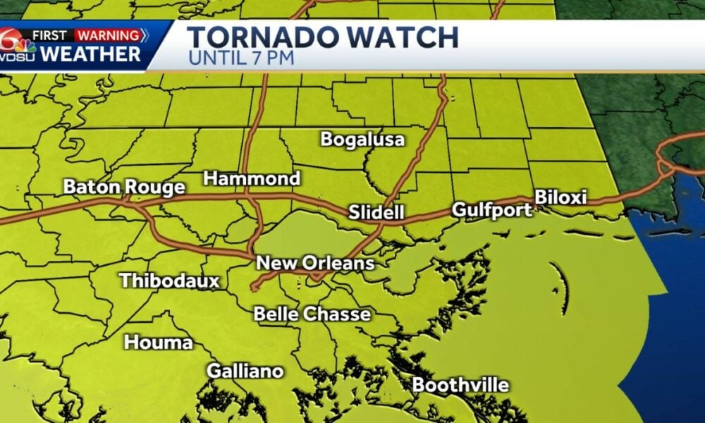
A wave of severe storms put southeast Louisiana on high alert on the evening of March 4, 2025, with a tornado warning issued for St. Bernard and Plaquemines Parishes until 8 p.m. CST, as Mardi Gras revelers faced dangerous weather conditions in New Orleans. The National Weather Service (NWS) extended a broader tornado watch across the region until 9 p.m., forecasting destructive winds up to 70 mph and the potential for isolated tornadoes on a day that began calmly but swiftly turned perilous. The mix of heavy rain and strong winds, moving at 40 mph eastward/northeast, threatens to disrupt Mardi Gras celebrations, which draw over 1.3 million visitors annually, while local authorities scramble to ensure safety amid parades and crowds.
The tornado warning, issued at 7:44 p.m. CST, covers vulnerable coastal areas like Chalmette and Belle Chasse, where gusts have already toppled trees and power lines in scattered incidents before the storms’ peak. Beyond tornado risks, a high wind warning is in effect until 9 p.m., with sustained gusts expected between 30 and 40 mph, and a coastal flood advisory warns of tides rising 2 feet above normal, impacting riverside communities. Though intense rains could dump up to 2 inches in hours, the storms’ rapid movement reduces widespread flooding risks but heightens the threat of localized damage. The NWS estimates 500,000 people in the New Orleans metro area are directly at risk, with the most critical conditions anticipated between 7 p.m. and 8 p.m.
As Mardi Gras parades like those of the Zulu and Rex krewes press on, New Orleans police have ramped up patrols and issued warnings for revelers to seek shelter if winds intensify or tornado signs emerge. Schools and businesses in affected parishes closed early, and Louis Armstrong International Airport reported delays on over 30 flights due to the weather. After the storms, expected to clear by 9 p.m., the region anticipates a reprieve with dry, comfortable weather through week’s end, but the immediate focus is minimizing the impact of a night testing the resilience of Louisiana’s most iconic celebration.
Storms intensify over New Orleans
Weather conditions in New Orleans shifted from calm to chaotic throughout March 4, with winds picking up after a mild morning. By 5 p.m. CST, the first storms formed, quickly escalating into a high-speed system moving at 40 mph, bringing heavy rain and gusts. The tornado warning for St. Bernard and Plaquemines, issued at 7:44 p.m., reflects an imminent tornado threat, while the region-wide watch until 9 p.m. covers parishes like Jefferson and Orleans, signaling widespread danger.
The NWS predicts the fiercest storms will sweep through between 7 p.m. and 8 p.m., with some cells moving as fast as 50 mph. These conditions could spawn damaging winds capable of downing trees and poles, echoing past events like the March 2022 tornadoes that caused $10 million in damages across the area. The storms’ swift pace curbs urban flooding risks, but power outages loom large, with Entergy Louisiana reporting 5,000 homes already dark by 7:30 p.m. near Chalmette.
High alert disrupts Mardi Gras festivities
Police and Mardi Gras organizers are on edge as storms collide with nighttime parades. Over 1.3 million visitors and 600,000 locals crowd New Orleans streets for the festivities, generating roughly $900 million in annual revenue. The tornado warning until 8 p.m. and watch until 9 p.m. prompted emergency tweaks, with smaller krewes like Orpheus delaying events, while major parades like Rex’s proceed under close watch.
Temporary shelters opened in schools and churches across St. Bernard and Plaquemines, and the Louisiana National Guard deployed 200 personnel to aid potential evacuations. Louis Armstrong International Airport, handling 40,000 passengers daily during Mardi Gras, saw delays on 35 flights by 7:45 p.m., with cancellations looming if winds top 50 mph. The blend of celebration and severe weather creates a tense scene, though authorities stress safety remains paramount as storms roll in.
Weather hazards test the region
The March 4 storms stem from a volatile Gulf of Mexico pattern, where cold fronts meet warm, moist air, fostering tornado-friendly conditions. The NWS logged 15 tornadoes in Louisiana in 2024, and this event could push that tally higher, with sustained winds of 30-40 mph and gusts up to 70 mph forecast until 9 p.m. Coastal flooding, with tides rising 2 feet, threatens low-lying areas like Pointe à la Hache, home to 2,000 residents.
Mardi Gras has weathered storms before—in 2019, heavy rains axed minor parades, costing $20 million in losses. This time, the storms’ 40 mph speed may limit flooding damage, but tornado and wind risks keep emergency crews on standby. Post-8 p.m. peak, conditions should ease by 9 p.m., ushering in dry weather, though the immediate priority is safeguarding the region.
Timeline of March storm surge
The storm progression follows a critical schedule:
- 5 p.m. CST: Initial storms form, with winds picking up in New Orleans.
- 7:44 p.m. CST: Tornado warning issued for St. Bernard and Plaquemines until 8 p.m.
- 9 p.m. CST: Tornado watch and high wind warning expire, storms expected to fade.
This timeline guides preparations as the region braces for peak impact.
Emergency measures ramp up against winds
Local officials are acting fast to curb risks. In St. Bernard, crews felled 50 at-risk trees by 6 p.m., while Plaquemines distributed 300 sandbags to shield coastal homes. New Orleans bolstered parade barricades, and 500 extra police were deployed to guide crowds if evacuations are needed.
Entergy Louisiana estimates 10,000 customers could lose power if winds topple lines, with repair teams on alert since 4 p.m. Schools in Chalmette shut down at 3 p.m., and Highway LA-23 closed vulnerable stretches by 7 p.m., reflecting urgent efforts to protect about 50,000 residents in the hardest-hit zones.
Storm highlights in focus
The weather event brings striking details:
- Winds up to 70 mph could damage 5% of homes in St. Bernard.
- Rain may drop 2 inches in under an hour, moving fast at 40 mph.
- 2-foot tides threaten 2,000 residents in Plaquemines’ coastal areas.
- Mardi Gras’ 1.3 million visitors face weather risks in New Orleans.
These figures underscore the event’s scale and intensity.
Mardi Gras resilience faces trial
Mardi Gras, with its 1.3 million visitors and $900 million economic boost, is under a resilience test. Major parades like Rex’s at 6 p.m. press on with adjustments, but police warn tornadoes could halt everything post-8 p.m. Shelters like St. Louis Cathedral opened at 7 p.m. for revelers, while hotels reported 20% cancellations by 7:30 p.m.
Once storms clear by 9 p.m., forecasts predict dry weather through the week, with highs of 65°F to 75°F. Recovery should be swift, but the current focus is ensuring Mardi Gras endures the severe weather without major losses, preserving its vibrant tradition amid meteorological chaos.
Veja Também:
 prêmio acumulado de R$ 5,5 milhões atrai milhões de apostadores no Brasil
 Samsung revela Galaxy S25 Edge com design ultrafino e câmera de 200 MP
 Timemania 2198 promete mudar vidas com prêmio acumulado de R$ 1,2 milhão
 datas de pagamento de fevereiro de 2025 e regras atualizadas do programa
 +Milionária 224, Quina 6656, Dupla Sena 2775, Lotomania 2734, Super Sete 657 e Lotofácil 3318 com prêmios milionários
 Quem pode ser eliminado no paredão do BBB 25 hoje? veja a enquete que aponta o possível eliminado